Category Archives: Interactive Maps

Participatory Civic Works Atlas

In the map below you will find cases of “civic works” reported to the pibinko.org network. By “civic works” we refer to restoration of old fountains, trail maintenance, art installations etc… the common trait is that these are projects created (and supported) by local communities**. If you click on a point you may see more details and, if available, access a page for more information. The map legend and the links are currently in Italian, but we will be glad to provide a full bi-lingual version of the atlas if enough cases from out of Italy emerge.

Map update: Aug. 25, 2025

** (for example, cases like “cleaning your village for one day” as a part of national campaigns is not relevant)

Updates

Aug 28 – We have added the “hand-made crochet Christmas trees” layers from our Dec. 2024 survey, as these are in fact community-made installations. For more information: https://www.pibinko.org/a-summary-of-the-first-italian-survey-of-hand-made-crochet-hook-christmas-trees/

European State Names in Italian Streets (version 1)

With the pibinko.org network we have started an analysis of street names in Italy, based on national open data records…always with an eye for lesser known situations (as we have been doing since 2007 in various contexts).

The reference to Greece is definitely prevailing in regions which are closer to the Hellenic peninsula…

Following a first experience with names of singers and songwriters (see link, in Italian), we decided to approach another category…European states. Below you will find the interactive map, where you can zoom around to check out where European state names are used in streets or squares of the Bel Paese.

Please note that this is a first round of the exercise…if you have names to add, or other comments to improve the analysis, please write to micalosapevo@pibinko.org or +393317539228. Furthermore, if you like this work, you may support the project (write to the same contacts to learn how).

The reference to”Jugoslavia” (or Iugoslavia, the red diamonds), has never been used in most of Northern Italy, while Balkan state names had a larger diffusion.

France takes the first position in the citations, followed by Hungary, Belgium, HoIland, and Greece in the first five positions.

Mountainous areas (in the Alps and the Appenine ridge) seem to be less prone to refer to singers or European states in their street names…

Thank you for your attention, and keep following the news in the pibinko.org network (or feel free to explore past articles, where you will find more lesser known insights)!

search termoccurrences
francia325
ungheria308
malta232
grecia205
spagna185
belgio178
germania159
olanda151
lussemburgo122
austria103
danimarca101
svizzera95
portogallo93
svezia84
polonia80
russia77
inghilterra76
norvegia66
albania63
irlanda62
romania59
finlandia54
montenegro47
bulgaria42
gran bretagna38
unione sovietica29
lituania27
jugoslavia24
slovenia24
croazia23
islanda21
andorra20
estonia18
cecoslovacchia17
scozia17
lettonia15
elvezia13
ucraina13
paesi bassi11
repubblica ceca11
repubblica di san marino9
gibilterra7
iugoslavia7
bosnia6
moldavia6
principato di monaco6
slovacchia5
bielorussia3
serbia3
cecoslovacca1
galles1
kosovo1
liechtenstein1

Notes:

  • In version 1 we have excluded “Paesi Bassi” (Netherlands), which has in any case 11 references
  • Some older version of names have been used (e.g. “Elvezia”)

A Survey of Street Names dedicated to non-classical musicians

The Italian statistics institute (ISTAT) as of August 2025 provides a list of streets, avenues, squares which have been named in time. There are a little over 1.2 million names. The top street names as “Roma”, “Giuseppe Garibaldi” (the national hero for the unification of the country in the 19th century), “Dante Alighieri” (the author of the Divine Comedy) etc….but there are a lot of lesser known street names which turn out to be curious.

As an example, we started looking for streets and squares dedicated to singers/songwriters. In the map below you can see the ones for Lucio Battisti (the green circles), Rino Gaetano (the yellow diamond), Luigi Tenco (the blue triangle). The size of the symbol is related to the size of the street or square, and clicking on a symbol will show the name of the municipality where it is located*.

If you live in Italy, you know of a street or a square dedicated to a singer/songwriter, and you would like to add to the map the distribution of that name, please write to micalosapevo@pibinko.org. Also, if you know of streets or squares named after singers, songwriters, and musicians in other countries around the world, please let us know! NOTE: this is not a hit parade!

For more maps in the pibinko.org network since 1994: https://www.pibinko.org/maps/

If you like the mapping initiatives by pibinko, you can support them (please contact micalosapevo@pibinko.org or +393317539228 for more information on how to do this).

  • Data source: Stradario ISTAT 4-8-2025
  • Photos: Wikipedia
  • Base map: OpenStreetMap

[1] Please note tha the locations used are the centroids of the municipal territory, since a given street or square may not just be located in the

No AI was involved in the creation of this article

The map of “ball” locations

Starting from the core of hamlets in Southern Tuscany, where palla eh!/palla a 21 is played, together with other localities we have interacted with for the game since 2007, here is an interactive map of “ball” (as in the variants of “jeux de paume“) places. We know that we start with gaps in regions where there are many locations (Piedmont, Spain, France, Belgium, The Netherlands, Latin America, etc.), but this is an open exercise.

To add a new location to the map, or to correct/integrate the existing information: micalosapevo@pibinko.org or whatsapp +393317539228.

Clicking on a point you may see additional information, if available.

If you like this map and you would like to support it: micalosapevo@pibinko.org or +393317539228 for more information.

last update: Apr. 18, 2025

Gran(i)Tour 2024: The Interactive Map

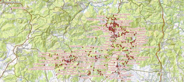
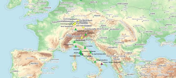
From this interactive map you may explore the various events in the tour (the yellow dots), and get information about other situations and characters related to this mission (friends, twist dancers, grain producers, etc). This map is frequently updated. Last update: Apr. 30, 2024.

Community Place Names

This map represents the progress in the collection of “community place names” in the pibinko.org network projects.

These are localities and other geographic features which currently are not represented in official base maps (namely, the 1:10000 so called “technical regional cartography”). For the various areas we have engaged, we indicated the starting year. All communities of the participating villages are acknowledged.

If you click on one of the points you will see a list of pibinko.org articles referring to that location.